
FEMA’s Outdated and Backward-Looking Flood Maps

The recent hurricanes, which inflicted severe damage from Puerto Rico to Texas’ Gulf Coast, have underscored the value of not only ensuring flood maps are accurate and up-to-date, but also that future conditions, like changing rainfall patterns, are accounted for in the depiction of flood risk. The Federal Emergency Management Agency (FEMA) is responsible for mapping the nation’s hazardous flood areas, including coastal areas susceptible to storm surge. However, a recent investigation by the Department of Homeland Security’s Inspector General revealed that 58% of all FEMA flood maps are considered inaccurate or out-of-date. Inaccurate and out-of-date flood maps put communities at risk.
Currently, Congress is set to reform and reauthorize the National Flood Insurance Program (NFIP) by December 8th. Congress should direct FEMA to include future conditions assessments as an information layer on all flood maps and to ensure that the process of creating and adopting flood maps receives proper oversight. Floodplain mapping reform must be a priority, and part of a comprehensive effort to reform the NFIP.
FEMA’s Flood Mapping Program
Congress enacted the NFIP to better protect the United States from flooding by providing a unified national program for floodplain management. The program provides more than cheap insurance, but also serves to promote sustainable floodplain development and flood risk identification. The program requires all three legs – insurance, mapping, and building and land use regulations – to function.
FEMA’s floodplain maps are a fundamental element of the flood insurance program, providing a basis for flood insurance rates and floodplain management regulations. The flood maps depict the 1% annual chance flood (100-year flood) and the .2% annual chance flood (500-year), and provide mapped communities with knowledge about their flood vulnerability. FEMA’s minimum floodplain building and land use requirements only apply in areas that are mapped to the 100-year flood level. As such, flood maps are used by government officials, developers, and planners to decide where it is safe to build. Therefore, FEMA’s flood maps must be accurate and up-to-date, otherwise, communities will be misinformed about their true flood exposure.
FEMA is required to update flood maps every five years. If a map is not assessed within the five-year window, the level of flood risk is considered “unknown.” FEMA must reassess flood maps regularly because flood risks are not static. Flood risks change over time due to a variety of factors, like changing land use patterns.
Climate change impacts, like rising sea levels and more intense rain storms, also influence flood risk. Climate change is loading the dice in favor of more frequent and severe floods. For example, as sea level rise, storm surge can reach further inland and affect a greater number of properties during a hurricane. However, FEMA’s flood maps do not currently depict future conditions. Instead, FEMA’s flood maps look backwards in time and determine the size of the 100-year and 500-year floodplain based on past events.
FEMA’s Flood Map Program Needs Reform
FEMA’s flood mapping program is falling short in protecting people and property from flooding. According to a September 2017 report by the Department of Homeland Security’s Office of Inspector General, FEMA is unable to “provide members of the public with a reliable rendering of their true flood vulnerability or ensure that NFIP rates reflect the real risk of flooding.” Almost 2/3rds of FEMA’s flood maps have not been updated in the last 5 years. Numerous communities have not had a map update in more than 30 years. For example, many areas that flooded when Sandy struck in 2012 had maps that were last updated in 1983.
Inaccurate and outdated flood maps are a significant problem, especially as FEMA provides flood maps for 22,000 communities across the United States. Faulty information about an area’s flood risk exposes the program to greater losses, as premium rates will not reflect true risk, and, also leave homeowners vulnerable, especially if their residences are incorrectly mapped out of the 100-year floodplain. Further, as mentioned above, communities rely heavily on these maps to guide their decisions about land use and development. FEMA’s flood maps are the determinant in where the minimum flood plain management regulations, i.e. building and land use codes, must be applied. If flood maps are inaccurate, these minimum building codes may only be applied in an area that is smaller than the true 100-year floodplain, which could leave new construction vulnerable.
Per the Inspector General’s report, FEMA needs to provide better management of flood mapping projects, including a uniform approach across all regions for processing such projects and better oversight on how flood mapping partners, like States and municipalities, comply with flood hazard data requirements. FEMA has concurred with the report’s findings and has committed itself to rectifying the identified problems.
However, even if FEMA could rectify the mapping programs shortcomings, new maps still will not provide an accurate depiction of risk due to the absence of future conditions projections, like sea level rise, changes in rainfall, and expected population growth.
FEMA Flood Maps Must Look Forward
FEMA’s flood maps must include future conditions projections to accurately depict flood risk. By 2100, the oceans could rise by as much as 9.8 feet along the East Coast of the United States, according to the latest projections from the National Oceanic and Atmospheric Administration. Three feet (0.9 meters) of sea level rise could affect the homes of 4.2 million Americans; a rise of six feet (1.8 meters) could affect 13.1 million.
Many areas are already experiencing the impacts of sea level rise. Increased incidents of tidal flooding (also known as “sunny day flooding”) are becoming common. These floods are not caused by a hurricane or a storm, but occur instead due to high tides. Places like Miami and Atlantic city are being repeatedly inundated by tidal flooding, and will continue to do so as sea levels become higher.
Riverine areas are also facing an increasing risk of flooding. A FEMA commissioned study found many inland floodplains could expand in size by 45 percent by 2100, which would in turn greatly increase the number of vulnerable properties.
If these changing flood dynamics are not taken into account, communities may choose to locate development in areas that appear safe from flooding today, but will be facing a serious flood risk tomorrow. FEMA’s flood maps need to include an information layer that depicts future conditions, including accounting for the impacts of climate change. A Federal advisory committee, established to review and make recommendations to FEMA on how to improve the mapping program, specifically recommended such an approach. FEMA should follow through on the recommendations and enact policy changes that would require future conditions to be included on FEMA’s flood maps.
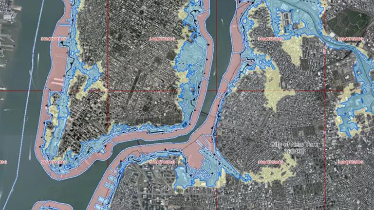
New York City Flood Maps Set the Mold
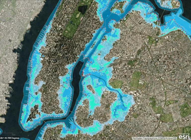
FEMA’s new flood maps for New York City will provide an important example for the rest of the nation. The new flood maps will account for the risk of sea level rise and coastal storm surge. These maps will help the city determine where to build, helping to protect people and property from future flood disasters.
Congress Should Direct FEMA to Map Future Conditions
FEMA’s flood maps are more than just mechanisms to set insurance rates. These maps provide risk information and enable communities to make informed decisions about their flood vulnerability. Too many flood maps are out-of-date, and those that are current still fail communities by not depicting future conditions like sea level rise. Congress has until December 8th to reauthorize the flood insurance program. Changes to the mapping program must be part of a comprehensive reform package, including additional directives to FEMA to account for future conditions on their flood mapping products.